The basic idea behind water movement (and more broadly all gravity based movement) is that it's always trying to go downhill by the quickest path. If water could move straight to the core of the planet, it would. The only reason it doesn't is because other material gets in the way. Liquid water will only stop moving when it is trapped by an impermeable material. As simple as this first idea is, it is essential to all that follows.
The second most important (and basic, sorry) point is that all of this water comes from somewhere. How it moves through the environment as a whole is aptly called the Water (or Hydrologic) Cycle.
 http://www.srh.weather.gov/jetstream/atmos/hydro_cycle.htm
 This cycle illustrates of some of the diversions and restarts that water goes through on its travel downhill.
Through the application of these simple concepts, the shape of rivers can be understood. In its quest to descend a quickly as possible, water encounters all kinds of material and (primarily through friction) erodes it. When water encounters a change in material or slope, it will turn to follow the path of least resistance. Water is lazy. These changes in material or slope account for all redirection of water flow. This means that when a river meanders (it's a technical term, really) across a landscape that there are underlying reasons for it.
As water flows downhill, it joins up with its buddies and they all work together to make life easier. Streams, brooks and rivulets get together to make rivers. Where they intersect, the course may be altered briefly depending on the sources relative flow rates and volumes of water. A very fast flowing stream may scour a pool where it meets a greater river, but do little to the overall direction. A low point where numerous streams meet may become a lake, whose outflow is the combined volume of all its feeders (the lake is purely a pass through, once full. think of a tub). Increasing the mass of the material involved in the flow increases the force applied proportionally.
Not all sources of water for a river are visible at the surface. Some water travels underground, through the soil, or through cracks in the rock. When I was in Brazil, I walked through a field of grasses (in Chapada) where the soil was so thin that the water basically flowed an inch under my feet. Groundwater can form springs where it reaches an impermeable material downhill becoming a feeder stream or it may feed directly into a river from the channel.

from Kniffen, F.B. 1968. Louisiana, its land and people. LSU Press
Rate of flow determines the sediment load of water, which increases its scour potential. The flow direction (illustrated in the diagram) identifies where the greatest scouring will occur along the banks. Eventually, the the ratio of energy loss (required to redirect the water flow) verses material strength may be overcome, cutting across the meander and creating an oxbow lake, island or towhead (generally re-straightening the course of the river).

The cross-sectional shape of rivers vary widely. Some are deep and narrow. Some are wide and shallow. When rivers have to pass through rock, they narrow and the rate of flow increases as a result (same amount of water after all). Likewise, when passing through a soft sediment (a nice sandy soil perhaps) a river will tend to spread out, as deeper soil is generally tighter packed. Changes in a river's proportional shape are always the result of a change in the material it is flowing through.
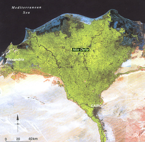
It is important to remember that every time flowing water slows down, it drops some of its sediment load (the Wiki on Sediment, subsection fluvial processes, is more in depth). This is how you get point bars, braided rivers, and so on. Obstructions in a river also have this impact, sometimes even forming islands amidst the flow. Some large rivers (Mississippi, Nile), when approaching the ocean, slow to such an extent that they drop the majority of their sediment load, forming deltas.
A river whose channel reaches the ocean will be influenced by tidal effects, raising and lowering river levels. Depending on the volume of water carried by the channel, salt water may even mingle with the fresh near the shoreline, creating what is called brackish water (which not many species enjoy). Some rivers (like the Amazon) maintain a high enough rate of flow that they carry fresh water well into the ocean proper.
By keeping in mind how water interacts with its environment, the positioning of rivers in their surroundings makes simple logical sense. The reasons for it my not be immediately apparent, but if we dig deeply enough, they are there.
As a writer I care about these things because I want to know what that mid-channel island (where the bandit camp is) is made of. I want to know how the fish got poisoned in this part of the river. I want to know where the water nymph's pool is located. Maybe I even want my seagoing vessel to be taking on fresh water while still afloat on the ocean. There are so many wonders on this planet Earth, it seems a shame not to incorporate some into yours.
No comments:
Post a Comment